Short version, if you're in a hurry
Namangan sits on the floor of the Fergana Valley — a fertile basin ringed by mountains on three sides. The walking logic here comes down to two things: summer heat and dust, winter inversion and smog. The valley traps air, and without wind it stagnates. That's why spring and autumn are when the city actually comes alive: bazaars piled with fruit, parks in bloom, the air smelling of apricots and mulberries
The basic rule: walk before 8 a.m. and after 7 p.m. in summer; walk after midday in winter. The city is fairly compact — Bobur Park, the old Otaboy bazaar, the Naryn riverfront can be linked on foot in a couple of hours. Real nature — the Chust foothills, the Aksay waterfalls, pomegranate orchards — is all within an hour by car
Pick a route
Route picker by steps and effort
Check the air and temperature first
Namangan sits in the Fergana Valley, which has its own climate. The valley is ringed by mountains, air stagnates, and on still summer days dust accumulates; in winter, smog from private boilers hangs around. Before heading out, check:
- IQAir / AirVisual — app and website. Sensors are scattered across the valley with data for Namangan, Andijan and Fergana. Easy color readout and hourly forecast
- uzhydromet.uz — official Uzhydromet. Temperature, wind, humidity from state stations. Updates less often but reliable
- Windy.com — for wind forecasts. In the valley, wind is the main air-cleaner: a couple of hours after a front the air is noticeably better
What the PM2.5 numbers (μg/m³) mean: 0–12 — clean, 13–35 — acceptable, 36–55 — short walk OK, no sport, 56+ — stay off the streets, especially kids and the elderly
Temperature rule of thumb: a "feels like" above +35°C makes serious effort dangerous. Plan on 0.5 L of water per hour of walking in summer. The valley UV index hits 9–10 in summer — don't go out at midday without a hat and sunscreen
City routes — where Namangan actually lives
1. Husayn-bek Square plaza
Length: ~1.2 km loop · Steps: ~2,500 · Elevation: flat
The dead centre of the historic city. The plaza by the Husayn-bek mosque, next to the old Otaboy bazaar and the start of the pedestrian streets. Old chinars, a fountain, benches. A perfect short loop for half an hour — between errands or after dinner. Mornings: traders and chess-playing pensioners. Evenings: young people and families
How to get there: any central marshrutka, "Husayn-bek" or "Old bazaar" stop
2. Yoshlar (Youth) Park
Length: ~2 km big loop · Steps: ~4,000 · Elevation: flat
One of the city's newer parks, in the Yangi-Shahar district. Tidy, with bike paths, workout zones and cafes. Trees are young, little shade at midday — hot during summer days. But on weekends it's notably less crowded than Bobur Park. Best in the evening when the lighting kicks in
How to get there: city buses and marshrutkas to Yangi-Shahar
3. Dustlik (Friendship) Park
Length: ~2.5 km loop · Steps: ~4,500 · Elevation: flat
One of the older city parks, with truly mature chinars and mulberry trees. A fountain, Soviet-era shaded avenues, an inexpensive teahouse. Mornings — joggers and pensioners; midday — moms with strollers; evenings — families and friends. One of the best parks for a hot day: dense canopies give honest shade
How to get there: marshrutkas from the centre, ~10 minutes
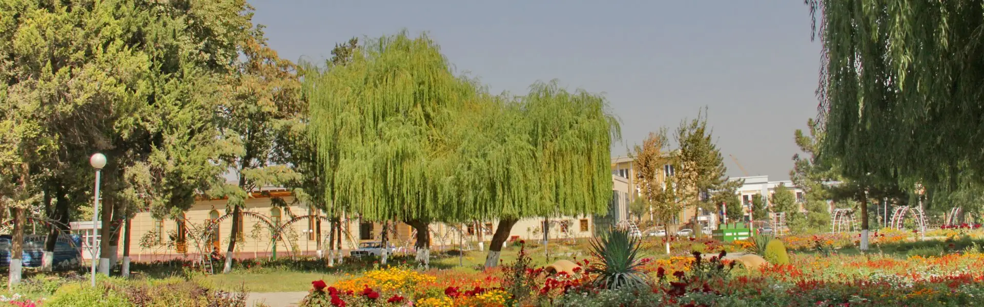
4. Bobur Park — the main one
Length: ~3.5 km main avenues · Steps: ~5,000 · Elevation: flat
Namangan's biggest and most central park — about 50 hectares. Named after Zahiriddin Muhammad Babur, founder of the Mughal Empire and a son of the Fergana Valley. At the centre stands a Babur statue, then long avenues, fountains, an artificial lake, rides, cafes. This is the pedestrian heart of the city: everyone walks, exercises and meets here. The main loop is 5,000 steps; with side paths up to 8,000
How to get there: any central route, "Bobur Park" stop
5. History loop: Husayn-bek → Mulla Kyrgyz → Khoja Amin
Length: ~4 km loop · Steps: ~6,000 · Elevation: flat
A walk with history, not just step count. Start at the Husayn-bek mosque, cross the old Otaboy bazaar to the early-20th-century Mulla Kyrgyz madrasa (still a functioning Quran school and a museum of architecture), and on to the 18th-century Khoja Amin mausoleum — Namangan's only surviving mausoleum. Along the way: quiet mahallas with mud-brick walls, craft shops, teahouses. Little shade, so summer means morning or evening only
How to get there: any central marshrutka to Husayn-bek Square
6. Naryn riverfront
Length: ~5 km one way · Steps: ~7,000 · Elevation: flat
The Naryn river splits the Fergana Valley in two and runs along Namangan's western edge. The riverbank has a city walking path — alleys, bridges, open views over the water and the valley beyond. This isn't a Tashkent-style polished promenade, more of a quiet edge with its own rhythm. Spaciousness, wind, almost no people on weekdays. Great if you're tired of city noise
How to get there: westbound marshrutkas to "Naryn" or "Kadiriya"
7. Bobur + Dustlik (linkup)
Length: ~5.5 km · Steps: ~8,000 · Elevation: flat
Two central parks linked into a single walking loop. Start at Bobur, cross the centre to Dustlik, return through the old town. The best urban route at the 8,000-step mark: shade, chinars, fountains, cafes and fruit stalls along the way. Sidewalks and pedestrian infrastructure throughout
How to get there: start at Bobur Park, finish in the centre
8. Big loop: Bobur → Otaboy → Husayn-bek → riverfront
Length: ~7 km loop · Steps: ~10,000 · Elevation: flat
The best long urban route in one loop. Start at Bobur Park, cross the centre to the old Otaboy bazaar (the legendary Namangan fruit market: pomegranates, apricots, dried mulberries), then to Husayn-bek Square, finishing on the Naryn riverfront. The chain lets you cover 10,000 steps without a car or repeats, with history, food and river views
How to get there: start at Bobur Park; from the riverfront take a marshrutka back
9. Tepa-Kurgan + "Sayyokh" complex
Length: ~5 km loop · Steps: ~11,000 (with climbs) · Elevation: 30–50 m
Tepa-Kurgan is an ancient archaeological hill on the city's eastern edge — the remains of a pre-Islamic fortification. The climb is gentle but rewards you with an honest panorama of all of Namangan and the Fergana Valley. Next to it sits the "Sayyokh" tourist complex with a hotel, cafes and a themed park. Good for a daytime walk with views, especially in the off-season
How to get there: eastbound city marshrutkas to "Sayyokh"
Out of town — where Fergana shows its honest face
10. Chust — town of craftsmen
Length: ~6–7 km around town · Steps: ~13,000 · Elevation: flat
Chust, 30 km northwest of Namangan, is a craftsmen's town with a global reputation: the famous "pichoq" knives, "Chust dopi" tubeteika caps, pomegranate orchards. The route is a slow walk through blacksmith workshops, the cap bazaar and quiet mud-brick mahallas. Along the way you'll find a mosque and madrasa. By midday you've easily covered 13,000 steps — while haggling, sipping pomegranate juice and watching a blade being forged
How to get there: marshrutkas from the "Yangi Namangan" bus station, ~40 min one way
11. Aksay — foothill waterfall
Length: 8–14 km depending on the trail · Steps: up to 20,000 · Elevation: 300–500 m
If you want real mountains and real air, this is it — the foothills of the Chatkal range, 50 km north of Namangan. The Aksay waterfall cascade, a gorge with crystal water, walnut groves and juniper. A serious day hike: the trail gets steep in places, the upper waterfall is roughly a 2-hour climb. Pack runners or trekking shoes, water and a hat. Best in late spring (May) and early autumn (September) — when the water is high and the valley isn't yet baking
How to get there: car or taxi only (~1 hour); public transport doesn't reach the trailhead. Better with a local guide
Seasons — when to go
Winter (December — February)
Mild compared to northern Uzbekistan: +0–10°C by day, often below freezing at night. The main problem is inversion: when the wind dies, the valley traps the air and smog from private boilers builds up through January and February. What to do: watch PM2.5 and wind, walk on clear windy days. In heavy smog stay home or escape up to the Chatkal mountains, above the inversion layer
Spring (March — May)
The best time of year in Namangan. Orchards in bloom — apricots, peaches, apples in April (Namangan grows up to 30 apple varieties), pomegranates in May. Temperatures +18–28°C, clear skies, soft air. What to do: March–April is peak for every walking route and trips to Chust and Aksay. By late May the heat is closing in on +30
Summer (June — August)
The main seasonal challenge. +35–42°C by day, +25 at night. The valley holds the heat — there's no real cooling off. What to do: walks strictly before 8 a.m. or after 7 p.m. Densely shaded parks (Dustlik, Bobur) and fountains save the day. Long routes — mornings only. Aksay is realistic only in the morning and when the springs still have water
Autumn (September — November)
The second peak after spring. Heat breaks by mid-September, bazaars overflow with the harvest: pomegranates, melons, grapes, walnuts. October Namangan is golden and well-fed. What to do: grab September and October, walk a lot. By late November first frosts may bring inversion and smog — keep watching the index
What to bring — short checklist
- Water — lots of it. 0.5 L per hour of walking in summer. In winter — at least 0.5 L
- A cap or hat. The valley sun is harsh 8 months of the year
- Sunscreen. SPF 30+ for face and arms in summer — not optional
- A light layer. Aksay mornings and evenings turn cold sharply, and so does the city in winter after sundown
- Comfortable shoes. Sandals and flip-flops turn into torture by 10,000 steps, especially in the old town
- A mask (for winter walks when PM2.5 is high)
- A charged phone. Aksay and the Chust foothills have weak signal — offline maps help
- Cash. Bazaars and teahouses don't always take cards
The takeaway
- Namangan has an honest air-quality hierarchy: Chatkal mountains > Bobur Park > downtown. In winter inversion the gap is huge
- The real enemies are summer heat and winter valley inversion, not climbs. The city is flat — every route is walkable
- The main park is Bobur (~50 ha), the pedestrian heart of the city
- The longest urban route is Bobur → Otaboy → Husayn-bek → Naryn — 10,000 steps in a single loop
- The most "historical" — Husayn-bek → Mulla Kyrgyz → Khoja Amin: mausoleums and madrasas on foot
- The most "natural" — Aksay and the Chust foothills: 30–50 km out, a day by car
- Seasons matter: best windows are March–May and September–October; in summer go only morning and evening
The rule is simple: in Namangan you can't walk at any time of day — summer sun and winter inversion don't forgive. But with five or six trusted spots and a couple of apps, you can hit 10,000 comfortable steps year-round. And Qozgal will count every step — no subscriptions, no ads, no extra noise
Count steps for free
Download Qozgal — accurate step counter via Apple Health and Health Connect, no subscriptions or ads