Short answer if you're in a hurry
Oskemen has an unusual mix for Kazakhstan: two rivers and mountains right at the edge of town. The Irtysh and the Ulba meet inside the city at Strelka headland, and the southern outskirts open onto the Rudny Altai with its trails. The whole logic of walking here boils down to two things: wind direction and which bank you're on. The industrial belt — the Ulba Metallurgical Plant, Kazzinc, the power station — runs along the western side. With a westerly wind, downtown and the left bank get hit immediately; with an easterly, the air comes off the Altai and is noticeably cleaner
Basic rule: walk closer to the Altai, away from the plants. Zhastar Park, Strelka, Aksai and the Botanical Garden are almost always solid choices. In winter the industrial backdrop is joined by typical East-Kazakhstan inversions — cold air with private-stove smoke sits over the city. On those days the only honest option is to head out to a hill or to the Sibiny lakes
Pick a route for your steps and energy
Route picker by steps and effort
Check the wind first
In Oskemen the main variable isn't the season — it's wind direction. The industrial belt (Ulba Metallurgical Plant, Kazzinc, the power station) runs along the western and north-western outskirts. With a westerly, everything from the chimneys drifts straight into the city centre and the left bank. With an easterly or north-easterly, the air comes off the Altai and is genuinely cleaner. Before heading out, glance at:
- Windy.com — app and website with hourly wind forecasts and direction. Arrows show where the wind comes from. If it's blowing west to east, walk on the eastern side (Left Bank, Strelka, Zhastar) and vice versa
- kazhydromet.kz — the official Kazhydromet, which has a station in Oskemen. PM2.5 and SO₂ data. Slow to update but reliable
- airkaz.org — a network of independent sensors. Coverage is thinner than in Almaty, but you can see neighbouring districts. Useful in winter when the smog gets thick
What the PM2.5 numbers mean (μg/m³): 0–12 — clean, 13–35 — fine for a walk, 36–55 — head for the hills or a dense park, 56+ — only go out if you have to, especially with kids or older people
City routes — pavement, parks and two rivers
1. Square by the Sports Palace
Length: ~1.2 km loop · Steps: ~2,500 · Profile: flat
The most central square in town. A fountain, benches, shaded poplars and elms. A perfect short walk before or after work — there's always activity here, kids on skateboards, parents with strollers. Too short for a serious walk, but a great starting point for a longer route
How to get there: any central marshrutka, downtown
2. Kirov Park
Length: ~1.8 km loop · Steps: ~3,500 · Profile: flat
Oskemen's oldest park, laid out in the Soviet era. Mature firs, alleys, kids' rides, an outdoor stage. Of all the city parks, this one has the largest trees — real shade and a real pollution buffer. Convenient for a quick lunch-break or evening walk
How to get there: Kirov Street, bus #2, 9, trolleybus #3
3. Botanical Garden
Length: ~2.5 km full loop · Steps: ~4,000
The Altai Botanical Garden covers 35+ hectares on Bazhov Street. A collection of trees and herbs from every corner of the Altai — cedars, larches, rare grasses. Paths between plots, almost no people on weekdays. Air is noticeably cleaner than the surrounding streets thanks to the dense conifer canopy. Symbolic entry fee
How to get there: bus #18, 32 to Bazhov Street
4. Victory Park (Zhenis)
Length: ~2.5 km big loop · Steps: ~4,500
A memorial park with an Avenue of Heroes, an eternal flame and Soviet-era military hardware. Even paths, shaded firs and birches, almost no traffic noise. Families come on weekends, retirees with outdoor gym kit on weekdays. A nice place for a calm, even-paced walk
How to get there: Independence Avenue area, bus #25, trolleybus #2
5. Zhastar (Youth) Park
Length: ~3.5 km big loop · Steps: ~5,500
The largest park in the city and its real "urban forest". Conifer alleys, a cycle lane, outdoor gyms, sports courts. Big trees around the perimeter, open lawns in the middle. Industrial noise is minimal because it's set back from the main avenues. Ideal for running and evening walks year-round
How to get there: Nazarbayev Street, bus #11, 33
6. Irtysh embankment — central section
Length: ~2.2 km one way · Steps: ~6,500 round-trip
The central stretch of the main embankment: a proper promenade, asphalt, benches every 100 m, lamp posts. Runners in the morning, strollers in the evening. The Irtysh is wide, the breeze off the water knocks down summer heat and helps disperse winter smog. From the bank you can see the right side of the city and the distant Altai
How to get there: bus #19, 25 to the embankment, trolleybus #1
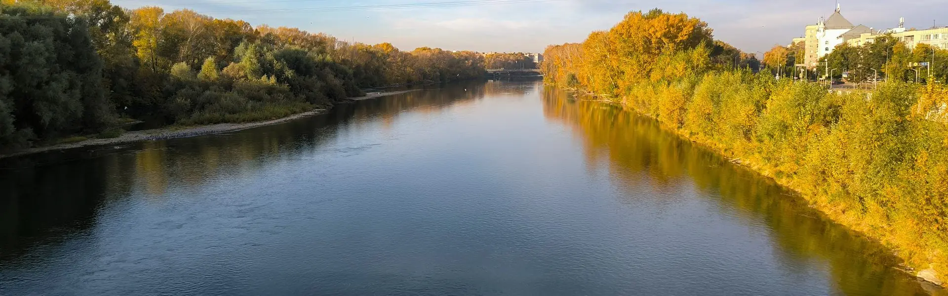
7. Irtysh → Strelka → Ulba loop
Length: ~7 km loop · Steps: ~10,000
The best long city loop in a single trip. Start at the central section of the Irtysh embankment, walk to the Left Bank Park, head onto Strelka headland — the point where the Irtysh and Ulba meet — and then loop back along the Ulba embankment to downtown. One river, then the headland between two waters, then the second river — the views constantly change and 10,000 steps go almost unnoticed
How to get there: start at the Irtysh embankment stop, bus #19 or #25
8. Left Bank → Strelka → Ulba embankment (long loop)
Length: ~9 km one way, ~13 km loop · Steps: ~18,000
The record city route in Oskemen. Start in the Left Bank district, walk along the embankment, cross the bridge to Strelka, then follow the Ulba embankment as far as the Oskemen hydroelectric dam or beyond into Zhastar Park. The route closes both your daily and weekly WHO targets. Cafés, shops and water points all the way; the lighting at night makes it comfortable after dark too
Mountain and out-of-town routes
9. Aksai — forest park and mountain
Length: ~6 km round-trip · Steps: ~13,000 · Elevation gain: 250 m
The most accessible "step into the Altai" straight from the city. On the southern outskirts, by the Aksai reservoir, a pine forest park begins, and from it a trail climbs to the summit of Mount Aksai. The ascent isn't hard — it switchbacks through pines and birches. From the top you get the whole panorama of Oskemen: the bend of the Irtysh, the power plant on the west, the Altai silhouette on the horizon. In summer it smells of pine and warm resin; in winter the trail makes a great cross-country ski track
How to get there: bus #35 to Aksai, then walk to the trailhead
10. Mount Kazan and the Aksai reservoir
Length: ~7 km loop · Steps: ~16,000 · Elevation gain: 300 m
The rocky ridge next to Aksai. The hike is a bit harder — in places it stops being a forest path and becomes a stony climb. But it's quieter and wilder: far fewer people, better views. Below the ridge lies the Aksai reservoir, easy to swing by for a cool break. A proper half-day outing — count on 3–4 hours including a rest at the top
How to get there: bus #35 to terminus, then walk, or drive to the trailhead
11. Sibiny lakes
Length: 8–15 km on trails · Steps: up to 22,000 · Elevation gain: 400 m
The most famous natural site near Oskemen. Five lakes squeezed between two granite ridges, 80 km from the city. Each lake has its own character: Bolshoye Sibinskoye is the deepest, Shalkar has a granite spine, Tortkara is the calmest. Trails through pine forest and over rocks connect them. Day trip logistics: about 1.5 hours one way on tarmac, then gravel; 4–5 hours of walking on site. Best season is June–September; in shoulder seasons the dirt roads can be wet and rutted
How to get there: car or organised tour only. A day tour usually costs 8,000–15,000 KZT per person, less in a group
Seasons — what works when
Winter (December — February)
Tough by Kazakh standards: −20°C is normal, −35°C does happen. On top of the cold come temperature inversions and smog from private-stove neighbourhoods. What to do: walk in the warmer midday hours, choose dense parks (Zhastar, Botanical Garden). For cross-country skiing, the Aksai forest is excellent. The Irtysh freezes; people walk on it in places, but going onto the ice without a guide is risky
Spring (March — May)
The best time after the snow. Leaves come out by late April, by May everything's green. What to do: catch April–May for Aksai and the Sibiny lakes — snow has gone, mosquitoes haven't peaked yet, +10–22°C. City parks come alive, the embankments open their summer terraces. The Irtysh breaks up dramatically — Strelka in that week is extremely photogenic
Summer (June — August)
Warm: +25–32°C, occasionally up to +35°C. Far more pleasant than southern Kazakhstan thanks to the proximity of the mountains. What to do: stay near water or in shade. Embankments, Zhastar, Botanical Garden. The Sibiny lakes are essential — July–August is peak swimming season. Aksai gets hot at noon, better to hike it in the morning or evening
Autumn (September — November)
The second peak after spring and, many locals would argue, the most beautiful season. The Altai slopes turn gold, the Irtysh becomes a mirror. What to do: get to Sibiny and Aksai before mid-October — the first snow comes after that. In town, spend as much time outside as possible before the heating season starts and brings smog with it
What to bring — a short checklist
- Water. 1.5 L for a mountain route (Aksai, Kazan); at least 2 L for the Sibiny lakes; a bottle for any city walk
- A warm layer or windbreaker. Even in summer the early morning by the water and in the hills is cool — Altai winds don't warm up until midday
- Trainers with grip. Pine needles and stones on the Aksai and Kazan trails — smooth soles slip
- Mosquito repellent. June through August, mandatory for Zhastar, the Botanical Garden, and especially the Sibiny lakes
- A cap or hat. The sun on the Altai foothills is harsher than it feels in summer
- A mask — if PM2.5 is high and the wind is blowing the wrong way
- A charged phone with offline maps. Coverage drops in places at Sibiny and is patchy in the Aksai forest
Bottom line
- Oskemen has a rare combination for Kazakhstan: two rivers and the Rudny Altai right at the edge of town
- The main variable isn't the season but wind direction. Industry sits to the west; an east wind brings clean air
- The most convenient city routes are the Irtysh and Ulba embankments, Strelka and Zhastar Park
- The longest city route is Left Bank → Strelka → Ulba — 18,000 steps
- The greenest are the Botanical Garden and Zhastar Park: dense conifers really do filter dust
- The most accessible mountains are Aksai and Kazan: a city bus, then 1–2 hours on a trail
- The most epic is the Sibiny lakes: 80 km, a full day out, 22,000 steps
- Seasons matter: best — May–September; in winter — Aksai forest park or the city parks
The simple rule: in Oskemen you can't just "walk wherever" — two rivers, industry to the west and the Altai to the south make the air radically different across the city. But knowing five or six trusted spots and a couple of apps lets you walk 10,000 clean-air steps year-round. And Qozgal will count every one — no subscriptions, no ads, no extra numbers
Count your steps for free
Download Qozgal — an accurate step counter using Apple Health and Health Connect. No subscriptions, no ads