Short version, if you're in a hurry
Aktau is a compact city on the Caspian shore, and walking here boils down to two constraints: summer sun and year-round wind. From May through September, asphalt heats up to +50°C, and UV on this coast is harsher than in Almaty or Astana. On the upside, the sea breeze knocks 4–6°C off the felt temperature — walking by the water genuinely feels better than walking inside any courtyard
The base rule: plan in-city routes along the sea, and head to Mangistau for any real hike. Inside town everything is compact — minutes between microdistricts on foot. The peninsula's wild nature, though — that rare Kazakh sense of total silence — is an hour out
Pick a route
Match a route by steps and effort
Check the wind and the temperature first
In Aktau, unlike Almaty or Tashkent, the main weather variable is not smog but wind. The Mangyshlak peninsula is exposed, and at 8 m/s walking the open shore turns into a fight. Before heading out, check: Windy.com for wind forecasts (anything above 7–8 m/s — stick to building cover), kazhydromet.kz for official temperature and humidity, and 2GIS for navigation (Aktau uses microdistrict numbers instead of street names — without 2GIS you'll be lost the first week)
For temperature: anything above a felt +35°C makes serious effort risky. Plan 0.5 L of water per walking hour in summer. UV on the coast often hits 9–10 — no hat, no cream, no walk at noon
City routes — paved, parks and the sea
1. Gulder Square + Veterans Alley
Length: ~1.2 km loop · Steps: ~2,500
The most central square in the 4th microdistrict. Fountain, benches, shade from young plane trees and hackberry. Perfect for a 30-minute break
2. Victory Park (Zhenis)
Length: ~2 km big loop · Steps: ~4,000
The oldest park in Aktau, near the 8th microdistrict. Memorial, alleys, and the only spot in town with truly mature trees throwing real shade
Getting there: buses 3, 5, 28 to the 8th microdistrict
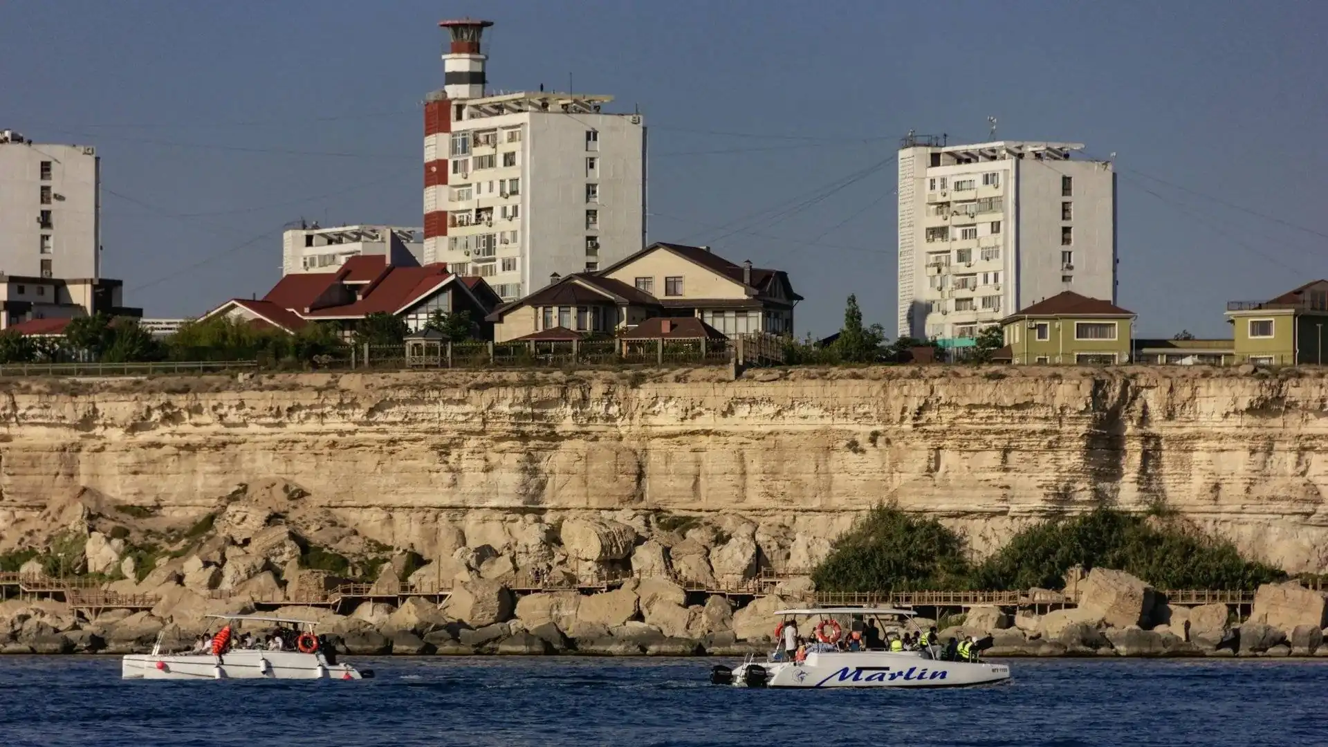
3. Lighthouse and 3rd microdistrict square
Length: ~2.5 km loop · Steps: ~4,500
The Aktau Lighthouse on every postcard. Open Caspian view from the lookout — the perfect sunrise or sunset spot. Stairs down the cliff lead to the beach in both directions
Getting there: bus 3 to the last stop
4. Yntymak (Friendship) Park
Length: ~2 km big loop · Steps: ~5,000
One of the new parks near the 11th microdistrict. Rest zones, bike paths, yoga decks. Trees are still young — sparse shade at noon
5. Cliffs and beach by the 14th microdistrict
Length: ~3 km along the shore · Steps: ~6,000
The wildest part of the urban shore. Yellow layered cliffs of shell rock, narrow beach, clear water. Almost empty on weekdays. The best place for a solo walk to the sound of the Caspian
Getting there: buses 3, 5 to the 14th microdistrict
6. Aktau promenade — short stretch (3rd → 5th microdistrict)
Length: ~3.5 km one way · Steps: ~7,000 round-trip
The central section of the main promenade: paved walkway, cycling lane, benches every 100 metres. Mornings belong to runners, evenings to families and roller-skaters
7. Loop: Lighthouse → promenade → 14th microdistrict
Length: ~7.5 km loop · Steps: ~10,500
The best long urban route in one loop. Start at the Lighthouse, walk the promenade past the central microdistricts, exit to the cliffs by the 14th. You hit 10,000 steps without noticing — the views keep changing
8. Full Aktau promenade
Length: ~5 km one way · Steps: ~14,000 round-trip
Aktau's longest urban route. From the Lighthouse to the 7th microdistrict square and back. Fully paved, cycling lanes, lit at night, cafés along the way. Closes both daily and weekly WHO activity targets
Outside the city — the Caspian and Mangistau
9. Bautino — beach spit
Length: ~7 km along the shore · Steps: ~16,000
A wild beach 30 minutes north of Aktau by car. Sand, shells, clear water, minimal infrastructure. A summer party scene; deserted and stunning in winter. Bring water and an umbrella — there's no shade
Getting there: car or taxi only, ~30 min
10. Sherkala — the yurt mountain
Length: 5–12 km depending on route · Steps: up to 18,000 · Elevation: 200–400 m
Mangistau's famous «yurt mountain», 180 km from Aktau. A solitary white rock in the middle of the steppe. Walk the perimeter (5 km) or climb the slope (a more serious hike). A full day trip — count 5–6 hours of driving plus the walk. Best at sunrise or sunset, when the rock turns gold
Getting there: car only, ideally with a guide or organised tour
11. Bozzhyra — canyon of white fangs
Length: 8–15 km on the plateau · Steps: up to 22,000 · Elevation: 100–300 m
Kazakhstan's most Martian place, 280 km from Aktau. Chalk towers like fangs, plateaus dropping tens of metres, total silence. The drive: 230 km of asphalt, then 50 km of serious dirt — 4×4 only. A day trip is brutal: 8 hours of driving for 4–5 hours on site. Better to overnight in a tent or a local yurt
Getting there: 4×4 with a guide. Going alone without proper gear is dangerous
Seasonality — what works when
Winter (December — February)
Mild compared to the rest of Kazakhstan: +0–10°C in the day, rarely below zero. The main enemy is the wind and damp from the sea. What to do: wind-blocking layers, hat mandatory. The promenade stays walkable but is empty and sometimes icy near the cliff stairs
Spring (March — May)
The best season. +15–25°C, the steppe greens, tulips bloom on the Ustyurt plateau. What to do: March–April is peak for every route and for trips into Mangistau. By late May the heat creeps to +30 and the wind picks up
Summer (June — August)
The hard season. +35–42°C in the day, UV 9–10, the sea wind itself is hot. What to do: walks strictly before 9 a.m. or after 7 p.m. The promenade (breeze) and Victory Park (mature trees) are the lifelines. Swim at sunset — the water hits +28 in the afternoon and stops cooling. For Sherkala or Bozzhyra — bring a serious water reserve
Autumn (September — November)
The second peak. Heat breaks by mid-September; October sits at a perfect +20–25°C. What to do: grab October–November and walk a lot. Cold winds arrive by late November — the «walking season» ends until March
What to bring — short checklist
- Plenty of water. 0.5 L per hour in summer. For Bozzhyra/Sherkala — at least 2 L per person
- A hat. Coastal UV is harsher than the continental interior
- Sunscreen. SPF 30+ for face, shoulders, arms — needed 9 months a year
- A windproof layer. Sea wind is cold even in summer mornings and evenings
- Solid shoes. Grippy soles — shell rock is slippery, especially when wet
- Sunglasses — sun off the sea is blinding
- A charged phone. Coverage drops near Bozzhyra — keep an offline map
Bottom line
- Aktau has an honest comfort hierarchy: promenade > parks > downtown. The sea breeze decides
- The enemies are summer sun and strong wind, not distance. The city is compact — everything is walkable
- The most convenient seaside routes are the Lighthouse, the promenade, the cliffs of the 14th microdistrict
- The longest urban route is the full promenade Lighthouse → 7th microdistrict, 14,000 steps round-trip
- The wildest is Bautino: 30 minutes by car and you have a beach to yourself
- The most epic is Sherkala and Bozzhyra: 2.5–4 hours into Mangistau for Martian views
- Seasonality matters: best windows are March–May and September–November; in summer, only morning and evening
The rule is simple: in Aktau you can't just walk «whenever» — sun, wind and the distance to Mangistau don't forgive bad prep. But knowing five or six trusted spots and a couple of apps lets you hit 10,000 comfortable steps year-round. And Qozgal will count every step — no subscriptions, no ads, no junk numbers
Count your steps for free
Get Qozgal — accurate step counter via Apple Health and Health Connect, no subscriptions and no ads